Houston topographic map
You can find on this page the Houston topographic map to print and to download in PDF. The Houston elevation map present the topography, river and relief of Houston in Texas - USA.
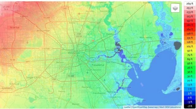
Houston elevation map
The Houston topographic map shows elevation, hills and landforms in Houston. This elevation map of Houston will allow you to know topography, river and relief of Houston in Texas - USA. The Houston topographic map is downloadable in PDF, printable and free.
Houston lies largely in the northern portion of the Gulf coastal plain, a 40- to 50-mile-wide swath along the Texas Gulf Coast. Typically, elevation rises approximately one foot per mile inland. Northern and eastern portions of the area are largely forested; southern and western portions are predominantly prairie grassland; coastal areas are prairie and sand. Surface water in the Houston region consists of lakes, rivers, and an extensive system of bayous and manmade canals that are part of the rainwater runoff management system. Some 25%-30% of Harris County lies within the 100-year flood plain. Elevation ranges (a.s.l.) as you can see in Houston elevation map: Brazoria 0’-146’, Chambers 0’-85’, Fort Bend 12’-158’, Galveston 0’-43’, Harris 0’-310’, Liberty 0’-269’, Montgomery 43’-435’, Waller 80’-357'.