Houston bus system map
You can find on this page the Houston buses map to print and to download in PDF. The Houston bus system map and the Houston trolley map present the network, stations and lines of the buses and trolley of Houston in Texas - USA.
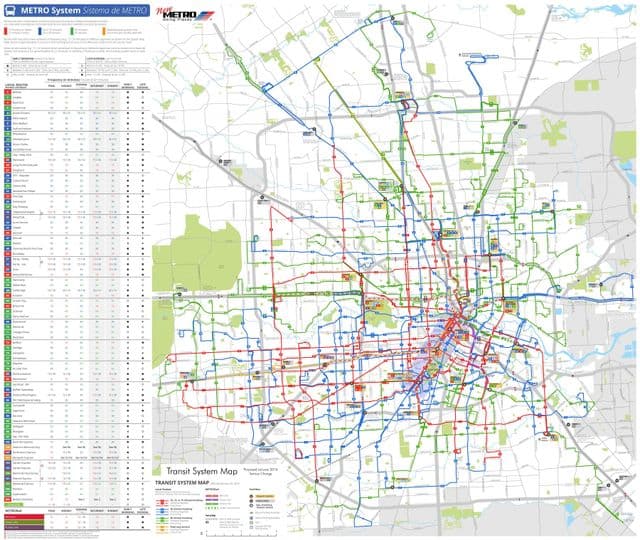
Houston bus map
The Houston bus map shows all the stations and lines of the Houston bus system. This bus map of Houston will allow you to easily plan your routes in the buses of Houston in Texas - USA. The Houston bus system map is downloadable in PDF, printable and free.
METRO has more than 1,200 buses as its shown in Houston bus map. With an extensive network of bus routes and convenient park-and-ride facilities helping to ease rush-hour commutes, the METRO Bus System keeps the Houston region moving. METRO is paving the way for a cleaner Houston with more than 440 transit diesel-hybrid buses in operation. Since 2003, METRO has been actively working to improve the air we breathe with state-of-the-art technology that reduces nitrogen oxide emissions by more than 50 percent and offers substantial savings in fuel. Hybrid technology is METRO current choice for vehicles, and each year, as part of its fleet replacement plan, METRO purchases 100 buses. The red network: These red routes are frequent routes with buses scheduled every 15 minute or less on 22 major routes, at least 15 hours a day – seven days a week. The blue network: These blue routes operate similarly to the red routes with buses scheduled every 16 to 30 minutes, 18 or more hours a day – seven days a week. The green network: These green routes offer buses every 31 to 60 minutes, at least 14 hours a day, seven days a week. This is designed to offer broad coverage in areas where there is light ridership.